Two Weeks in Kyrgyzstan by Car: A 1,000 km Self-Drive Loop Through Mountains, Lakes, and the Chinese Border
The full route from Bishkek through western Kyrgyzstan, Son-Kul, Kel-Suu, Issyk-Kul's south shore, and back — with road conditions, costs, and the kind of detail that Google Maps won't give you
Most travelers who rent a car in Bishkek head straight east toward Issyk-Kul. Fair enough — it is a great lake. But the real Kyrgyzstan is the loop. West through the Suusamyr valley and Toktogul reservoir. South to Son-Kul. Further south to the Chinese border, where yaks graze at 3,500 meters and a lake disappears into underground caves. Then east along Issyk-Kul's wild south shore, through red canyons and glacier plateaus, back to Bishkek.
This is a real itinerary: two weeks, roughly 1,000 km of serious driving, two people, one rental car from Bishkek. Nights in tents, yurts, and the back seat. Below — every stop, every road surface, every meal worth remembering.
Landing in Bishkek: SIM Cards, Cash, and Getting on the Road

The flight lands at Manas International Airport (BSZ), about 25 km from Bishkek. First moves: buy a local SIM card at the terminal, exchange currency (US dollars work, but som is essential for roadside purchases), and collect your rental car.
If your route includes border zones near China, you will need a border permit. These cost around $35 and should be arranged in advance — processing takes several days. Your car rental company in Bishkek can often advise on the process.
Around Bishkek: Quick Stops Before the Big Drive
- Chunkurchak: a ski resort and zip-line area about 30–40 km from the city. Good half-day trip.
- Osh Bazaar: stock up on dried fruit, bread, and snacks for the road. Prices are low.
- Manty: steamed dumplings filled with lamb. A Kyrgyz staple — try them before you leave the capital.
Driving West: Toktogul Reservoir and Hidden Mountain Lakes
The road from Bishkek toward Osh is one of the most scenic highways in Central Asia. It crosses the Too-Ashuu pass (over 3,000 m) through a three-kilometer tunnel, then drops into the high-altitude Suusamyr valley. Fuel is cheap — roughly $0.90 per liter at the time of this trip.
By sunset: the Toktogul Reservoir, Kyrgyzstan's largest body of water — over 60 km long, ringed by mountains. We pitched a tent on the shore in the dark and woke up to warm September water and a view that justified the drive.
Side Trip: Lake Kara-Suu
Thirty kilometers of rough gravel leads to Lake Kara-Suu — a turquoise mountain lake that almost no tourists reach because the road is so bad. Worth the detour if your vehicle can handle it. Full 4x4 recommended.
Burana-Tash Canyon
Near the town of Tash-Kumyr, a turnoff leads to the Burana-Tash Canyon — wind-carved rock formations that look remarkably like Turkey's Cappadocia. Smaller, quieter, and free.
Sary-Chelek Biosphere Reserve: A UNESCO-Listed Alpine Lake
The Sary-Chelek reserve is part of the UNESCO international biosphere network. At its center — a lake over 200 meters deep, with water that shifts between turquoise and dark navy depending on the light. Dense forest, wildlife, and six smaller lakes hidden in the surrounding hills.
The southern stretch of this route runs close to the Uzbek border. Towns like Jalal-Abad carry a noticeably Uzbek cultural influence — the food, the architecture, the market buzz. Try the samsa (baked meat pastry) and kumys (fermented mare's milk).
Son-Kul: Sleeping in Yurts at 3,000 Meters

The road to Son-Kul climbs through a mountain pass over 3,000 meters on a gravel road that is still being built in places. We nearly ran out of fuel. We passed nomadic families in solitary yurts. We ate real plov cooked over an open flame.
Then, after a nighttime gravel slog to a yurt camp at 3,000 meters, dawn came — and Son-Kul appeared. Kyrgyzstan's second-largest lake, surrounded by empty grassland and low hills. Wild beaches, total silence. The yurts are heated with dried dung (kizyak), and if that sounds rustic, it is. Also unforgettable.
- Access season: end of June through September. Earlier or later, the passes may be closed.
- Road: gravel, steep, sometimes narrow. 4x4 strongly preferred.
To the Chinese Border: Chatyr-Kul and the Vanishing Lake of Kel-Suu
South of Son-Kul, the route enters a different Kyrgyzstan. Leaving via the pass nicknamed "33 Parrots" and stopping at the "Big Brother" waterfall, we drove toward the Chinese frontier.
Chatyr-Kul: The Salt Lake That Doesn't Freeze
At 3,500 meters, the high-altitude salt lake Chatyr-Kul sits in a landscape that feels more Mongolian than Central Asian. Barren, vast, windswept. Along the 80 km approach, we passed Soviet-era border watchtowers and herds of yaks — animals perfectly built for thin air and bitter cold.
We spent the night in the car at below-zero temperatures. Not glamorous. Deeply memorable.
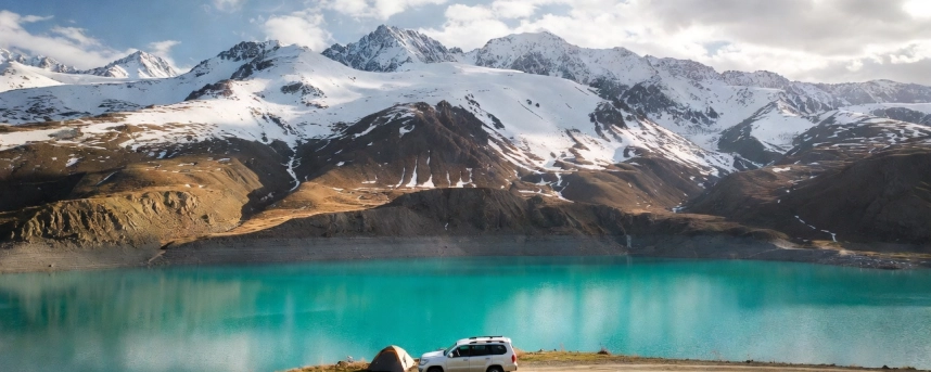
Kel-Suu: A Lake That Disappears

From the road, a 6 km hike over a pass reaches Kel-Suu — a 9-kilometer lake of turquoise water, wedged between sheer cliffs by an ancient landslide. The lake's water level depends on underground cave systems, and in some years it drains almost completely. We rented a boat and paddled directly into the rock caves.
- Border permit required. Arrange in Bishkek before departure.
- Expect snow even in September. We woke in a blizzard.
- Road back: rough enough that we punctured two tires on the return.
Issyk-Kul's South Shore: Skazka Canyon, Barskoon, and the Arabel Plateau

After the border zone, reaching Issyk-Kul feels like arriving in civilization. The lake is enormous — 180 km long, 700 meters deep, and it never freezes. The south shore is the interesting side.
Skazka (Fairy Tale) Canyon

Bright red and orange formations carved by wind into shapes that resemble everything from castles to alien terrain. Easy to reach from the main road. One to two hours to explore on foot.
Barskoon Gorge: From Gagarin to Glaciers
Barskoon packs history and geography into one gorge. There is a monument to Yuri Gagarin, who vacationed here in 1964. Three waterfalls with dramatic names — "Tears of the Snow Leopard," "Champagne Spray," and "Bowl of Manas." Above the waterfalls, the road climbs past the Kumtor gold mine to the Arabel Plateau — a high-altitude tableland that looks like Arctic tundra, complete with ice-covered lakes in midsummer.
Jeti-Oguz: The Seven Bulls

Red sandstone formations that look like seven reclining bulls. About 25–30 km from Karakol. The nearby Valley of Flowers (Kok-Jayik) is a gentle trek through wildflower meadows. We hiked to the "Girl's Braids" waterfall at night in the rain — not recommended, but the flowers the next morning made up for it.
The Ghost Town of Enilchek and Karakol's Hot Springs

From Karakol, a challenging drive over the Chon-Ashuu pass (3,800+ meters) leads to the abandoned town of Enilchek — built in the 1980s for a tin mine, now a ghost town with empty apartment blocks. Seven kilometers from the settlement, we soaked in the wild Karatazh hot springs at 60°C. The return at night, on an icy and avalanche-prone switchback road, was the most intense driving of the entire trip.
Altyn-Arashan and Ak-Suu

A 15 km hike from Karakol reaches the Altyn-Arashan valley — radon-infused thermal springs in a valley of old-growth forest. Afterward, the Ak-Suu Kench pools near town are a gentler option for tired legs.
Karakol Itself

The Dungan (Chinese Muslim) community here has built a mosque entirely without nails. Their cold noodle dish ashlyanfu is one of the best things we ate in two weeks. Also: baursaki (fried dough) from a street stall, eaten on a bench overlooking the mountains.
Back to Bishkek: By Plane Over the Mountains
Rather than drive back, we flew — a 50-minute flight from Karakol that covers hundreds of kilometers over the Tien Shan. The view from the window is worth the $50 ticket.
Bishkek itself surprised us. A green, sprawling city of over a million people, where Soviet apartment blocks sit next to new residential towers. The Osh Bazaar is enormous. The central Ala-Too Square has a towering statue of Manas, the national epic hero. The Ala-Archa National Park is a 30–40-minute drive from town — alpine scenery without needing a full day commitment.
Which Car Do You Actually Need for This Route?
This loop crosses three tiers of road. Match the car to your plan:
- Main highways (Bishkek–Osh road, north Issyk-Kul): any sedan. Smooth asphalt. Chevrolet Monza or Hyundai Elantra work fine.
- Gravel with moderate difficulty (south Issyk-Kul, Skazka Canyon, Jeti-Oguz): crossover with 4WD. Toyota RAV4, Wildlander, Hyundai Santa Fe.
- Serious mountain roads (Son-Kul, Kel-Suu, Enilchek, Arabel Plateau, Kara-Suu): full 4x4 SUV. Toyota 4Runner, Land Cruiser, Lexus LX 470. Non-negotiable.
For this specific itinerary, you need a 4x4 for the entire trip — the hardest sections define the vehicle choice. At Nomad Car Rental (nomadcar.kg), the SUV fleet starts from around $95–110/day, with OSAGO and CASCO insurance. Mileage: 300 km/day, accumulated across the rental. Airport delivery at Manas. If the Chon-Ashuu pass at night sounds like more than you want to handle, they also offer car rental with a driver.
Practical Notes for the Full Loop
- Fuel: fill up at every opportunity. Between Son-Kul and Kel-Suu, there is nothing. We nearly ran dry.
- Tires: carry a spare and know how to change it. We punctured two on the Kel-Suu return.
- Cold at altitude: even in September, nights at 3,500 m drop below zero. A warm sleeping bag is essential.
- Border permits: required for Chatyr-Kul and Kel-Suu. Arrange in Bishkek, not at the checkpoint.
- Offline maps: cell signal disappears in gorges and at altitude. Download Maps.me or OsmAnd before leaving Bishkek.
- Food: roadside cafes serve lagman (pulled-noodle soup), shorpo (meat broth), plov (rice with lamb), samsa (baked pastry), and kuurdak (fried meat). Eat local. It is cheap, filling, and often excellent.
- Budget: fuel around $0.90/liter. Yurt stays $10–25/night with meals. Hotel in Karakol $15–30. Internal flight Karakol–Bishkek around $50.
The Two-Week Itinerary at a Glance

Days 1–2. Bishkek: airport, SIM card, car pickup, border permit, Chunkurchak, Osh Bazaar.
Day 3. Drive west: Too-Ashuu pass, Suusamyr valley, Toktogul Reservoir. Camp on the shore.
Day 4. Lake Kara-Suu (rough gravel detour). Burana-Tash Canyon. Continue south.
Day 5. Sary-Chelek Biosphere Reserve. Drive toward Jalal-Abad.
Day 6. Mountain pass (3,000+ m). Nomadic yurts. Drive to Son-Kul yurt camp.
Day 7. Son-Kul sunrise. Drive south via "33 Parrots" pass. Chatyr-Kul. Night in car at 3,500 m.
Day 8. Hike to Kel-Suu. Boat ride through caves. Camp near lake.
Day 9. Return to main road (tire punctures likely). Drive to south shore of Issyk-Kul. Skazka Canyon.
Day 10. Barskoon gorge: waterfalls, Arabel Plateau, glacier views.
Day 11. Jeti-Oguz (Seven Bulls, Valley of Flowers). Drive to Karakol.
Day 12. Enilchek ghost town. Karatazh hot springs. Night return over Chon-Ashuu pass.
Day 13. Altyn-Arashan hike. Ak-Suu pools. Dungan mosque and ashlyanfu in Karakol.
Day 14. Fly Karakol → Bishkek. Ala-Archa National Park. Departure.
Why Drive the Full Loop

The east side of Kyrgyzstan — Issyk-Kul, Karakol, Jeti-Oguz — is beautiful, well-documented, and relatively easy to reach. The west and south are harder, rougher, and far less visited. Son-Kul at dawn, Kel-Suu in a snowstorm, the silence of Chatyr-Kul with yaks on the horizon — these are not highlights from a brochure. They are the moments that make you rethink what travel can be.
For the full loop, you need a vehicle that handles gravel at altitude, fords shallow rivers, and gets you home when the pass ices over at midnight. Rent a car in Bishkek at nomadcar.kg — 4x4 SUVs with insurance, accumulated mileage, airport delivery, and English-language support. Then point the wheel west, where most tourists don't go, and see what happens.
-

Places for Photos on Issyk-Kul
09.04.2025 -

What do you need to know when renting a car in Kyrgyzstan?
09.04.2025 -

Mountain route to Lenin Peak
09.04.2025 -

What to visit in Kyrgyzstan: the beauty of the land of mountains and lakes
09.04.2025 -

Which car should you choose for a trip around Kyrgyzstan?
09.09.2025


